![](/images/other/stat-length.png)
![Randonnée Vélo de route La Croix-Valmer - Croix Valmer - Ste Maxime A/R - Photo](https://media.geolcdn.com/t/1900/400/ext.pjpeg?maxdim=2&url=https%3A%2F%2Fstatic1.geolcdn.com%2Fsiteimages%2Fupload%2Ffiles%2F1524743154velo.jpg)
Croix Valmer - Ste Maxime A/R
fhascoet
Utilisateur
![Longueur](/images/other/stat-length.png)
![Altitude max](https://static1.geolcdn.com/siteimages/upload/files/1508320355ic_sort_altitude_max_24dp.png)
![Dénivelé positif](https://static1.geolcdn.com/siteimages/upload/files/1508320355ic_sort_den_pos_24dp.png)
![Km-Effort](/images/other/stat-length.png)
![Altitude min](https://static1.geolcdn.com/siteimages/upload/files/1508320355ic_sort_altitude_min_24dp.png)
![Dénivelé négatif](https://static1.geolcdn.com/siteimages/upload/files/1508320355ic_sort_den_neg_24dp.png)
![Boucle](https://static1.geolcdn.com/siteimages/upload/files/16400158638029165_repeat_loop_refresh_sync_direction_icon.png)
![Vélo de route](https://static1.geolcdn.com/sitytour/trail-icons/201.png)
6h00
Difficulté : Moyen
![Scannez ce code QR pour ouvrir la randonnée dans l'application SityTrail](https://capi.geolives.com/qq0zvz2zws4bq2lad0pu/sitytour/trails/2694753/qr.png?size=200)
Application GPS de randonnée GRATUITE
À propos
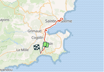
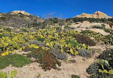
Randonnée Vélo de route de 45 km à découvrir à Provence-Alpes-Côte d'Azur, Var, La Croix-Valmer. Cette randonnée est proposée par fhascoet.
Description
passage dans Port Grimaud - montée au sémaphore de Ste Maxime
Bonne piste cyclable sauf au passage de l'echangeur de Cogolain plage où l'on est abandonné à notre triste sort au milieu des voitures (surtout problématique au retour) .
Localisation
Commentaires
Randonnées à proximité
![Randonnée A pied La Croix-Valmer - La Croix Valmer - Gigaro - Taillat - Collebasse - Gigaro - Photo](https://media.geolcdn.com/t/375/260/a03cc7dc-d40c-427d-bc15-d4c3c8fead2d.jpg&format=jpg&maxdim=2)
![A pied A pied](https://static1.geolcdn.com/sitytour/trail-icons/100.png)
A pied
![](/images/other/stat-length.png)
![](https://static1.geolcdn.com/siteimages/upload/files/16400158638029165_repeat_loop_refresh_sync_direction_icon.png)
![Randonnée Vélo électrique La Croix-Valmer - Rayol -Oppidum version 2 - Photo](https://media.geolcdn.com/t/375/260/fc5cd018-661e-4f17-bef8-76baca0d8415.jpg&format=jpg&maxdim=2)
![Vélo électrique Vélo électrique](https://static1.geolcdn.com/sitytour/trail-icons/205.png)
Vélo électrique
![](/images/other/stat-length.png)
![](https://static1.geolcdn.com/siteimages/upload/files/16400158638029165_repeat_loop_refresh_sync_direction_icon.png)
![Randonnée Marche La Croix-Valmer - LCV RANDO COURTE COLLINES - Photo](https://media.geolcdn.com/t/375/260/ext.jpg?maxdim=2&url=https%3A%2F%2Fstatic1.geolcdn.com%2Fsiteimages%2Fupload%2Ffiles%2F1553511878bg_sport_marche.png)
![Marche Marche](https://static1.geolcdn.com/sitytour/trail-icons/101.png)
Marche
![](/images/other/stat-length.png)
![](https://static1.geolcdn.com/siteimages/upload/files/16400158638029165_repeat_loop_refresh_sync_direction_icon.png)
![Randonnée Marche Cogolin - Gavotte- Bagueirède sud - Peinier - Bord de Mole - Photo](https://media.geolcdn.com/t/375/260/ext.jpg?maxdim=2&url=https%3A%2F%2Fstatic1.geolcdn.com%2Fsiteimages%2Fupload%2Ffiles%2F1553511878bg_sport_marche.png)
![Marche Marche](https://static1.geolcdn.com/sitytour/trail-icons/101.png)
Marche
![](/images/other/stat-length.png)
![](https://static1.geolcdn.com/siteimages/upload/files/16400158638029165_repeat_loop_refresh_sync_direction_icon.png)
![Randonnée Vélo électrique La Croix-Valmer - Rayol -Oppidum - Photo](https://media.geolcdn.com/t/375/260/fc5cd018-661e-4f17-bef8-76baca0d8415.jpg&format=jpg&maxdim=2)
![Vélo électrique Vélo électrique](https://static1.geolcdn.com/sitytour/trail-icons/205.png)
Vélo électrique
![](/images/other/stat-length.png)
![](https://static1.geolcdn.com/siteimages/upload/files/16400158638029165_repeat_loop_refresh_sync_direction_icon.png)
![Randonnée V.T.T. Ramatuelle - Ramatuelle moulins de Paillas et Patapans.gpx - Photo](https://media.geolcdn.com/t/375/260/ext.jpg?maxdim=2&url=https%3A%2F%2Fstatic1.geolcdn.com%2Fsiteimages%2Fupload%2Ffiles%2F1524743154velo.jpg)
![V.T.T. V.T.T.](https://static1.geolcdn.com/sitytour/trail-icons/202.png)
V.T.T.
![](/images/other/stat-length.png)
![](https://static1.geolcdn.com/siteimages/upload/files/16400158638029165_repeat_loop_refresh_sync_direction_icon.png)
![Randonnée Marche La Croix-Valmer - Cap Lardier - Photo](https://media.geolcdn.com/t/375/260/ext.jpg?maxdim=2&url=https%3A%2F%2Fstatic1.geolcdn.com%2Fsiteimages%2Fupload%2Ffiles%2F1553511878bg_sport_marche.png)
![Marche Marche](https://static1.geolcdn.com/sitytour/trail-icons/101.png)
Marche
![](/images/other/stat-length.png)
![](https://static1.geolcdn.com/siteimages/upload/files/16400158638029165_repeat_loop_refresh_sync_direction_icon.png)
![Randonnée Marche Cavalaire-sur-Mer - Cavalaire 2 - Photo](https://media.geolcdn.com/t/375/260/66220656-f369-437d-a3c4-6a7ae56dd908.jpg&format=jpg&maxdim=2)
![Marche Marche](https://static1.geolcdn.com/sitytour/trail-icons/101.png)
Marche
![](/images/other/stat-length.png)
![](https://static1.geolcdn.com/siteimages/upload/files/16400158638029165_repeat_loop_refresh_sync_direction_icon.png)
![Randonnée Marche La Croix-Valmer - GIGARO . cap Taillat. AB -1 - Photo](https://media.geolcdn.com/t/375/260/816705b7-121a-4690-b7dd-3111fd3ff4d3.jpg&format=jpg&maxdim=2)
![Marche Marche](https://static1.geolcdn.com/sitytour/trail-icons/101.png)
Marche
![](/images/other/stat-length.png)
![](https://static1.geolcdn.com/siteimages/upload/files/16400158638029165_repeat_loop_refresh_sync_direction_icon.png)